
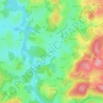
Le Crot topographic map
Interactive map
Click on the map to display elevation.
About this map
Name: Le Crot topographic map, elevation, terrain.
Average elevation: 452 m
Minimum elevation: 383 m
Maximum elevation: 571 m
Other topographic maps
Click on a map to view its topography, its elevation and its terrain.
Gouvault
France > Bourgogne-Franche-Comté > Nièvre > Brassy
Gouvault, Brassy, Château-Chinon (Ville), Nièvre, Bourgogne-Franche-Comté, France métropolitaine, 58140, France
Average elevation: 460 m
Les Brévières
France > Bourgogne-Franche-Comté > Nièvre > Brassy
Les Brévières, Brassy, Château-Chinon (Ville), Nièvre, Bourgogne-Franche-Comté, France métropolitaine, 58140, France
Average elevation: 444 m
La Chaume
France > Bourgogne-Franche-Comté > Nièvre > Brassy
La Chaume, Brassy, Château-Chinon (Ville), Nièvre, Bourgogne-Franche-Comté, France métropolitaine, 58140, France
Average elevation: 482 m
L'Huis du Mèe
France > Bourgogne-Franche-Comté > Nièvre > Brassy > L'Huis du Mèe
L'Huis du Mèe, Brassy, Château-Chinon (Ville), Nièvre, Bourgogne-Franche-Comté, France métropolitaine, 58140, France
Average elevation: 460 m