
Le Grand Hohnack topographic map
Interactive map
Click on the map to display elevation.
About this map
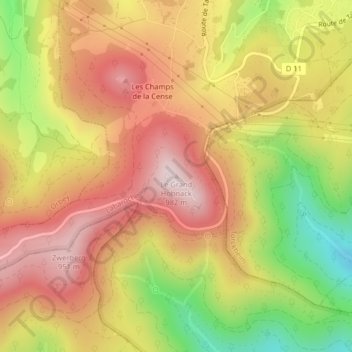
Name: Le Grand Hohnack topographic map, elevation, terrain.
Average elevation: 763 m
Minimum elevation: 489 m
Maximum elevation: 964 m
Other topographic maps
Click on a map to view its topography, its elevation and its terrain.
Château du Hohnack
France > Grand Est > Labaroche
Château du Hohnack, Piste d'Exploitation Forestière, La Place, Labaroche, Colmar-Ribeauvillé, Haut-Rhin, Grand Est, France métropolitaine, 68910, France
Average elevation: 775 m