Geolocate

Box Springs topographic map

Click on the map to display elevation.

About this map

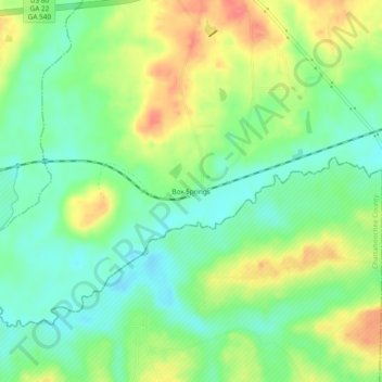
Name: Box Springs topographic map, elevation, terrain.

Location: Box Springs, Talbot County, Georgia, 31801, United States (32.51264 -84.68104 32.55264 -84.64104)

Average elevation: 124 m

Minimum elevation: 97 m

Maximum elevation: 163 m

Other topographic maps

Click on a map to view its topography, its elevation and its terrain.

Flint River

United States > Georgia > Talbot County

Average elevation: 225 m

Geneva

United States > Georgia > Talbot County

Average elevation: 164 m

Woodland

United States > Georgia > Talbot County

Average elevation: 231 m

Junction City

United States > Georgia > Talbot County

Average elevation: 203 m

Gear up for your next adventure:

🍽️Titanium Camping Spork - Ultralight and indestructible eating utensil
🥾Approach Boots - Comfortable boots for hiking and climbing approaches
🎒Hiking Backpack - Lightweight and ergonomic backpacks for day hikes or multi-day treks
🕯️Camping Lantern - Illuminates your entire campsite with high-efficiency LEDs
🧼Biodegradable Camp Soap - Environmentally friendly cleaning for gear and body

As an Amazon Associate, this site earns from qualifying purchases at no extra cost to you.