Geolocate

Radebeul topographic map

Click on the map to display elevation.

About this map

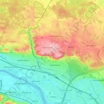
Name: Radebeul topographic map, elevation, terrain.

Location: Radebeul, Meißen, Saxony, 01445, Germany (51.08851 13.58531 51.14286 13.70111)

Average elevation: 163 m

Minimum elevation: 98 m

Maximum elevation: 249 m

Gear up for your next adventure:

🔨Vehicle Emergency Tool - Safety tool for remote road trips to trailheads
🦶Anti-Blister Balm - Prevents friction and hotspots during long ascents
🔪Outdoor Multitool - Versatile tool for repairs and food prep in the wild
🐕Hiking Dog Pack - Let your canine companion carry their own water and food
🕶️Polarized Sunglasses - Reduces glare from snow and water at high elevations

As an Amazon Associate, this site earns from qualifying purchases at no extra cost to you.