Geolocate

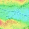
KG Innere Stadt topographic map

Click on the map to display elevation.

About this map

Name: KG Innere Stadt topographic map, elevation, terrain.

Location: KG Innere Stadt, Vienna, Austria (48.19953 16.35521 48.21849 16.38489)

Average elevation: 184 m

Minimum elevation: 156 m

Maximum elevation: 218 m

Other topographic maps

Click on a map to view its topography, its elevation and its terrain.
Wienerberg

Austria > Vienna

Average elevation: 223 m

Schonbrunn Palace

Austria > Vienna

Average elevation: 214 m

Belvedere

Austria > Vienna

Average elevation: 190 m

Wienerberg

Austria > Vienna

Average elevation: 223 m

Maurer Wald

Austria > Vienna

Average elevation: 307 m

Belvedere

Austria > Vienna

Average elevation: 190 m

Belvedere

Austria > Vienna

Average elevation: 190 m

Herweghpark

Austria > Vienna

Average elevation: 208 m

People's Garden

Austria > Vienna

Average elevation: 191 m

Gear up for your next adventure:

🧭GPS Handheld Device - Reliable GPS navigation for outdoor adventures
🔪Outdoor Multitool - Versatile tool for repairs and food prep in the wild
🔥Emergency Fire Starter - Reliable ignition source for all weather conditions
🧣Evaporative Cooling Towel - Beat the heat during intense summer climbs
🧼Travel Hand Sanitizer - Keep hands clean when water is scarce

As an Amazon Associate, this site earns from qualifying purchases at no extra cost to you.