Geolocate

Diadi topographic map

Click on the map to display elevation.

About this map

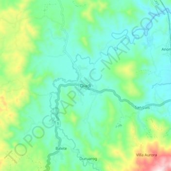
Name: Diadi topographic map, elevation, terrain.

Location: Diadi, Nueva Vizcaya, Cagayan Valley, 3712, Philippines (16.62062 121.32933 16.70062 121.40933)

Average elevation: 309 m

Minimum elevation: 158 m

Maximum elevation: 764 m

Other topographic maps

Click on a map to view its topography, its elevation and its terrain.

Kasibu River

Philippines > Nueva Vizcaya > Kasibu

Average elevation: 866 m

Kayapa

Philippines > Nueva Vizcaya

Average elevation: 1,258 m

Gear up for your next adventure:

🛶Canoe Life Vest - Safety vest for water sports
🕶️Polarized Sunglasses - Reduces glare from snow and water at high elevations
🩹Compact First Aid Kit - Pre-packed essentials for common trail injuries
🧴Outdoor Sunscreen - High SPF protection for high-altitude UV exposure
🦶Anti-Blister Balm - Prevents friction and hotspots during long ascents

As an Amazon Associate, this site earns from qualifying purchases at no extra cost to you.