Geolocate

Erqi District topographic map

Click on the map to display elevation.

About this map

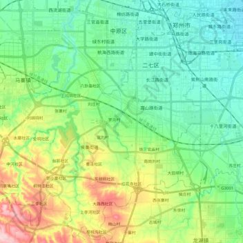
Name: Erqi District topographic map, elevation, terrain.

Location: Erqi District, Zhengzhou, Henan, China (34.60188 113.49726 34.77026 113.67641)

Average elevation: 153 m

Minimum elevation: 92 m

Maximum elevation: 302 m

Other topographic maps

Click on a map to view its topography, its elevation and its terrain.

Huayuankou

China > Henan > Zhengzhou

Average elevation: 91 m

Gear up for your next adventure:

🧼Biodegradable Camp Soap - Environmentally friendly cleaning for gear and body
🪜Heavy Duty Carabiners - Multi-use clips for securing gear to your backpack
🧢Beanie Hat - Keep your head warm in cold weather
🧼Travel Hand Sanitizer - Keep hands clean when water is scarce
🧥Softshell Jacket - Windproof and breathable jacket for hiking

As an Amazon Associate, this site earns from qualifying purchases at no extra cost to you.