Geolocate

Oderen topographic map

Click on the map to display elevation.

About this map
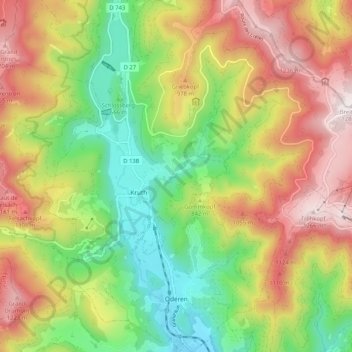
Name: Oderen topographic map, elevation, terrain.

Location: Oderen, Thann-Guebwiller, Haut-Rhin, Grand Est, Metropolitan France, 68830, France (47.89924 6.94358 47.96829 7.03669)

Average elevation: 822 m

Minimum elevation: 442 m

Maximum elevation: 1,278 m

Other topographic maps

Click on a map to view its topography, its elevation and its terrain.
Kurze

France > Grand Est > Haut-Rhin > Kunheim

Average elevation: 186 m

Gear up for your next adventure:

🚑Survival Whistle - Signal for help across long distances in mountains
🧥Waterproof Hiking Jacket - Protect yourself from rain and wind while hiking
🥾Hiking Gaiters - Protect legs and shoes from mud, snow, and debris
📷Outdoor Action Camera - Capture high-elevation views and rugged adventures
☕Camping Coffee Maker - Brew fresh coffee anywhere on the topographic map

As an Amazon Associate, this site earns from qualifying purchases at no extra cost to you.