Geolocate

Kundayithode topographic map

Click on the map to display elevation.

About this map

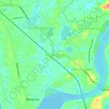
Name: Kundayithode topographic map, elevation, terrain.

Location: Kundayithode, Kozhikode, Kerala, 673015, India (11.17545 75.79841 11.21545 75.83841)

Average elevation: 13 m

Minimum elevation: -2 m

Maximum elevation: 40 m

Other topographic maps

Click on a map to view its topography, its elevation and its terrain.

Oloppara

India > Kerala > Kozhikode > Chelannur > Chirattatu colony

Average elevation: 20 m

Mananchira

India > Kerala > Kozhikode > Kozhikode

Average elevation: 12 m

Sarovaram Bio Park

India > Kerala > Kozhikode > Erenjippalam

Average elevation: 14 m

Kuthiravattom

India > Kerala > Kozhikode > Kozhikode > Pottammal

Average elevation: 17 m

Gear up for your next adventure:

🥾Trail Hiking Socks - Comfortable socks to prevent blisters and fatigue
🥾Light Trekking Boots - Supportive boots for multi-day treks
💧Collapsible Water Bottle - Space-saving water bottle for outdoor activities
🥾Trekking Boots - Durable boots for long-distance trekking
🔭Compact Monocular - One-handed bird watching and trail spotting

As an Amazon Associate, this site earns from qualifying purchases at no extra cost to you.