Geolocate

Dietmannsried topographic map

Click on the map to display elevation.

About this map

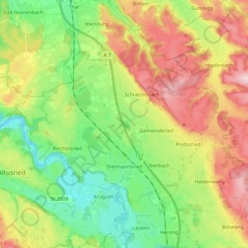
Name: Dietmannsried topographic map, elevation, terrain.

Location: Dietmannsried, Landkreis Oberallgäu, Bavaria, 87463, Germany (47.79009 10.18594 47.86376 10.35298)

Average elevation: 741 m

Minimum elevation: 629 m

Maximum elevation: 900 m

Gear up for your next adventure:

🧢Beanie Hat - Keep your head warm in cold weather
💧Filtered Water Bottle - Safe drinking water on the go
💡LED Headlamp - Hands-free illumination for night hiking and camping
🥾Lightweight Hiking Boots - Boots for comfort and mobility on long hikes
🥾Trail Hiking Socks - Comfortable socks to prevent blisters and fatigue

As an Amazon Associate, this site earns from qualifying purchases at no extra cost to you.