
Thank you for supporting this site ❤️
Make a donation
Make a donation
Gear up for your next adventure:
As an Amazon Associate, this site earns from qualifying purchases at no extra cost to you.
Pera Pedi topographic map
Click on the map to display elevation.
Thank you for supporting this site ❤️
Make a donation
Make a donation
Gear up for your next adventure:
As an Amazon Associate, this site earns from qualifying purchases at no extra cost to you.
About this map
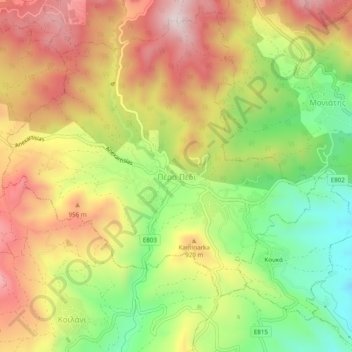
Name: Pera Pedi topographic map, elevation, terrain.
Location: Pera Pedi, Limassol District, Cyprus, 4776, Cyprus (34.84069 32.85435 34.88069 32.89435)
Average elevation: 835 m
Minimum elevation: 570 m
Maximum elevation: 1,092 m
Thank you for supporting this site ❤️
Make a donation
Make a donation
Gear up for your next adventure:
As an Amazon Associate, this site earns from qualifying purchases at no extra cost to you.