
Make a donation
Gear up for your next adventure:
As an Amazon Associate, this site earns from qualifying purchases at no extra cost to you.
King Island topographic map
Click on the map to display elevation.
Make a donation
Gear up for your next adventure:
As an Amazon Associate, this site earns from qualifying purchases at no extra cost to you.
About this map
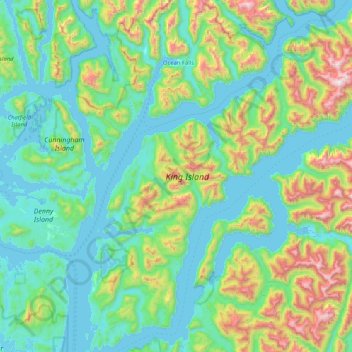
Name: King Island topographic map, elevation, terrain.
Average elevation: 330 m
Minimum elevation: -1 m
Maximum elevation: 1,678 m
Make a donation
Gear up for your next adventure:
As an Amazon Associate, this site earns from qualifying purchases at no extra cost to you.
Other topographic maps
Click on a map to view its topography, its elevation and its terrain.
Namu
Canada > British Columbia > Central Coast Regional District > Area A (Ocean Falls/Outer Coast)
Average elevation: 126 m
Panorama Ridge
Canada > British Columbia > Central Coast Regional District > Area C (Hagensborg/Talchako/Atnarko)
Average elevation: 2,203 m
Dawsons Landing
Canada > British Columbia > Central Coast Regional District > Area A (Ocean Falls/Outer Coast)
Average elevation: 207 m
Bella Coola
Canada > British Columbia > Central Coast Regional District > Area E (West Bella Coola/Clayton Falls/Tallheo)
There is a 454 km mostly paved road connection by Highway 20 to Williams Lake. The road was built in 1953 by local residents, and features a 15 km ascent from the Valley floor to the Chilcotin plateau, gaining 1600m in elevation to the summit at Heckman Pass, via a number of steep grades & switchbacks. The…
Average elevation: 437 m
Make a donation
Gear up for your next adventure:
As an Amazon Associate, this site earns from qualifying purchases at no extra cost to you.
Wadhams
Canada > British Columbia > Central Coast Regional District > Area A (Ocean Falls/Outer Coast)
Average elevation: 254 m
Telegraph Creek
Canada > British Columbia > Central Coast Regional District > Area C (Hagensborg/Talchako/Atnarko)
Average elevation: 1,432 m
Clyak Estuary Conservancy
Canada > British Columbia > Central Coast Regional District > Area A (Ocean Falls/Outer Coast)
Average elevation: 426 m