
Make a donation
Gear up for your next adventure:
As an Amazon Associate, this site earns from qualifying purchases at no extra cost to you.
Hammelburg topographic map
Click on the map to display elevation.
Make a donation
Gear up for your next adventure:
As an Amazon Associate, this site earns from qualifying purchases at no extra cost to you.
About this map
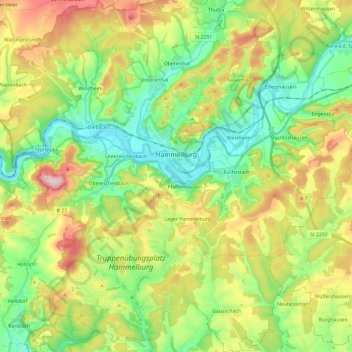
Name: Hammelburg topographic map, elevation, terrain.
Location: Hammelburg, Landkreis Bad Kissingen, Bavaria, 97762, Germany (50.02965 9.77917 50.18320 9.96553)
Average elevation: 285 m
Minimum elevation: 168 m
Maximum elevation: 484 m
Make a donation
Gear up for your next adventure:
As an Amazon Associate, this site earns from qualifying purchases at no extra cost to you.
Other topographic maps
Click on a map to view its topography, its elevation and its terrain.
Hammelburg
Germany > Bavaria > Landkreis Bad Kissingen > Hammelburg > Hammelburg
Average elevation: 260 m
Make a donation
Gear up for your next adventure:
As an Amazon Associate, this site earns from qualifying purchases at no extra cost to you.
Bad Kissingen
Germany > Bavaria > Landkreis Bad Kissingen > Bad Kissingen > Bad Kissingen
Average elevation: 295 m