Geolocate

Kelberg topographic map

Click on the map to display elevation.

About this map
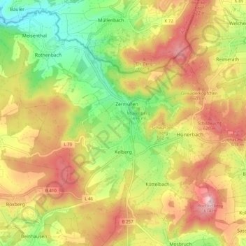
Name: Kelberg topographic map, elevation, terrain.

Location: Kelberg, Landkreis Vulkaneifel, Rhineland-Palatinate, 53539, Germany (50.26345 6.85917 50.32421 6.95749)

Average elevation: 527 m

Minimum elevation: 393 m

Maximum elevation: 660 m

Other topographic maps

Click on a map to view its topography, its elevation and its terrain.
Gear up for your next adventure:

💧Reusable Water Bottle - Durable water bottles for hydration on trails
🥾Hiking Shorts - Breathable shorts suitable for summer hikes
🛰️Satellite Messenger - Emergency communication for areas with no cell service
🌡️Emergency Mylar Blankets - Compact thermal protection for unexpected nights outdoors
⛺Tent Footprint - Protect tent floor and increase durability

As an Amazon Associate, this site earns from qualifying purchases at no extra cost to you.