
Make a donation
Gear up for your next adventure:
As an Amazon Associate, this site earns from qualifying purchases at no extra cost to you.
Herrlesberg/Stäudach topographic map
Click on the map to display elevation.
Make a donation
Gear up for your next adventure:
As an Amazon Associate, this site earns from qualifying purchases at no extra cost to you.
About this map
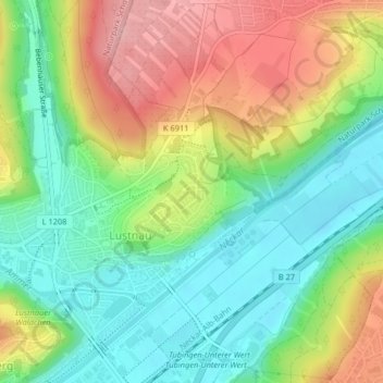
Name: Herrlesberg/Stäudach topographic map, elevation, terrain.
Average elevation: 371 m
Minimum elevation: 306 m
Maximum elevation: 465 m
Make a donation
Gear up for your next adventure:
As an Amazon Associate, this site earns from qualifying purchases at no extra cost to you.
Other topographic maps
Click on a map to view its topography, its elevation and its terrain.
Pfrondorf
Deutschland > Baden-Württemberg > Landkreis Tübingen > Tübingen > Pfrondorf
Average elevation: 410 m
Lichtenberger Höhe
Deutschland > Baden-Württemberg > Landkreis Tübingen > Tübingen
Average elevation: 353 m
Sengental
Deutschland > Baden-Württemberg > Landkreis Tübingen > Tübingen > Bühl
Average elevation: 412 m
Make a donation
Gear up for your next adventure:
As an Amazon Associate, this site earns from qualifying purchases at no extra cost to you.
Sengental
Deutschland > Baden-Württemberg > Landkreis Tübingen > Tübingen > Bühl
Average elevation: 412 m