Geolocate

Blackhawk topographic map

Click on the map to display elevation.

About this map

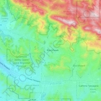
Name: Blackhawk topographic map, elevation, terrain.

Location: Blackhawk, Contra Costa County, California, United States (37.79812 -121.95191 37.83930 -121.87214)

Average elevation: 300 m

Minimum elevation: 145 m

Maximum elevation: 617 m

Gear up for your next adventure:

🥾Durable Hiking Shoes - Long-lasting shoes for frequent hiking
🦌Outdoor Trail Camera - Monitor wildlife activity near your favorite spots
🩹Moleskin Blister Pads - Direct protection for painful foot pressure points
🧥Ultralight Puffy Jacket - Maximum warmth that packs down to the size of an orange
🥾All-Terrain Hiking Boots - Versatile boots for varied hiking conditions

As an Amazon Associate, this site earns from qualifying purchases at no extra cost to you.