Geolocate

Pindugangan topographic map

Click on the map to display elevation.

About this map

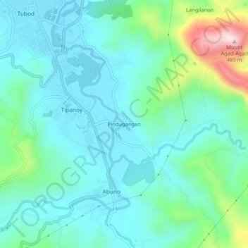
Name: Pindugangan topographic map, elevation, terrain.

Location: Pindugangan, Iligan, Northern Mindanao, 9200, Philippines (8.17556 124.23902 8.21556 124.27902)

Average elevation: 102 m

Minimum elevation: 5 m

Maximum elevation: 474 m

Other topographic maps

Click on a map to view its topography, its elevation and its terrain.

Kiwalan

Philippines > Iligan

Average elevation: 74 m

Mandulog River

Philippines > Iligan > San Roque

Average elevation: 79 m

Iponan River

Philippines > Iligan

Average elevation: 563 m

Bayug River

Philippines > Iligan > Lanipao

Average elevation: 154 m

Iligan City Wet Park

Philippines > Iligan

Average elevation: 17 m

Gear up for your next adventure:

Camping Groundsheet - Protect your tent from moisture and dirt
🥾Hiking Leggings - Comfortable leggings for outdoor activities
💧Reusable Water Bottle - Durable water bottles for hydration on trails
🎒Backpack Rain Cover - External shield to keep your entire pack dry
🗺️Topographic Maps - Detailed maps to explore trails, mountains, and wilderness areas

As an Amazon Associate, this site earns from qualifying purchases at no extra cost to you.