Geolocate

Ayton topographic map

Click on the map to display elevation.

About this map

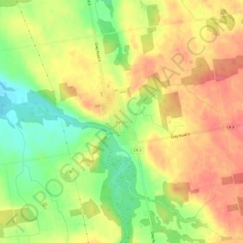
Name: Ayton topographic map, elevation, terrain.

Location: Ayton, West Grey, Grey County, Ontario, N0G 1C0, Canada (44.03367 -80.94564 44.07367 -80.90564)

Average elevation: 336 m

Minimum elevation: 299 m

Maximum elevation: 363 m

Grey County trails, hiking, mountain biking, running and outdoor activities

Other topographic maps

Click on a map to view its topography, its elevation and its terrain.

Louise Lake

Canada > Ontario > Grey County > West Grey

Average elevation: 314 m

Saugeen River

Canada > Ontario > Grey County > West Grey

Average elevation: 342 m

Gear up for your next adventure:

🥾Durable Hiking Shoes - Long-lasting shoes for frequent hiking
Tent Footprint - Protect tent floor and increase durability
🧣Merino Neck Gaiter - Protects against wind, sun, and cold at high altitudes
🧢Sun Hat - Wide-brim hat for sun protection
🧊Portable Cooler - Keep food and drinks cold during outdoor adventures

As an Amazon Associate, this site earns from qualifying purchases at no extra cost to you.