
Make a donation
Gear up for your next adventure:
As an Amazon Associate, this site earns from qualifying purchases at no extra cost to you.
San Pedro de Atacama topographic map
Click on the map to display elevation.
Make a donation
Gear up for your next adventure:
As an Amazon Associate, this site earns from qualifying purchases at no extra cost to you.
San Pedro de Atacama
The town lies at an average of 8,000 feet (2,400 m), thus visitors often experience mild altitude sickness such as dizziness, lethargy and headaches. The local climate is extremely dry and mild, with daytime temperatures between 25–30 degrees Celsius (77–86 degrees Fahrenheit) in the summer (December to February) and 18–25 °C (64–77 °F) in the winter (June to August). Nighttime temperatures routinely drop below 0 °C (32 °F) and can reach as low as −10 °C (14 °F) in the winter. The record high temperature of 38.3 °C (100.9 °F) was registered in January 2024 in San Pedro de Atacama.
Make a donation
Gear up for your next adventure:
As an Amazon Associate, this site earns from qualifying purchases at no extra cost to you.
About this map
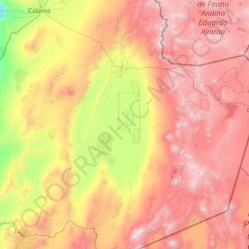
Name: San Pedro de Atacama topographic map, elevation, terrain.
Average elevation: 3,428 m
Minimum elevation: 1,560 m
Maximum elevation: 6,150 m
Make a donation
Gear up for your next adventure:
As an Amazon Associate, this site earns from qualifying purchases at no extra cost to you.
Other topographic maps
Click on a map to view its topography, its elevation and its terrain.
Toconao
Chile > Antofagasta Region > Provincia de El Loa > San Pedro de Atacama
Toconao is a village 38 km (24 mi) south of San Pedro de Atacama in the San Pedro de Atacama province of Chile's northern Antofagasta Region. It lies at an elevation of 2,485 m (8,153 ft) above sea level, close to the northeast margin of the Salar de Atacama.
Average elevation: 2,488 m