Geolocate

Gernsheim topographic map

Click on the map to display elevation.

About this map

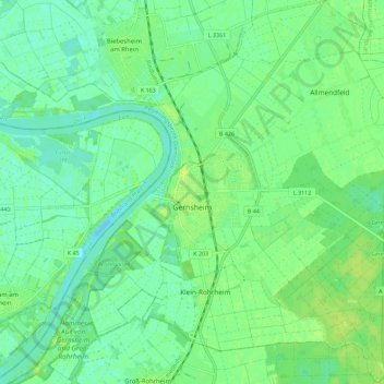
Name: Gernsheim topographic map, elevation, terrain.

Location: Gernsheim, Kreis Groß-Gerau, Hesse, 64579, Germany (49.71671 8.44836 49.79007 8.56202)

Average elevation: 91 m

Minimum elevation: 83 m

Maximum elevation: 99 m

Gear up for your next adventure:

🥾Trail Hiking Socks - Comfortable socks to prevent blisters and fatigue
🕯️Camping Lantern - Illuminates your entire campsite with high-efficiency LEDs
🧦Thermal Socks - Warm socks for winter hiking or camping
🥾Trekking Poles - Adjustable trekking poles to reduce knee stress and improve stability
🔭Outdoor Binoculars - Lightweight binoculars for birdwatching and hiking

As an Amazon Associate, this site earns from qualifying purchases at no extra cost to you.