
Hereford topographic map
Interactive map
Click on the map to display elevation.
About this map
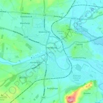
Name: Hereford topographic map, elevation, terrain.
Location: Hereford, Herefordshire, England, United Kingdom (52.02838 -2.77475 52.07766 -2.67251)
Average elevation: 68 m
Minimum elevation: 44 m
Maximum elevation: 185 m
Other topographic maps
Click on a map to view its topography, its elevation and its terrain.
Wigmore
United Kingdom > England > Herefordshire
Wigmore, Herefordshire, England, United Kingdom
Average elevation: 167 m
Cradley
United Kingdom > England > Herefordshire
Cradley, Herefordshire, England, United Kingdom
Average elevation: 127 m
Merryhill
United Kingdom > England > Herefordshire > Brinsop
Merryhill, Brinsop, Herefordshire, England, HR4 7HH, United Kingdom
Average elevation: 139 m