Geolocate

Nafra topographic map

Click on the map to display elevation.

About this map

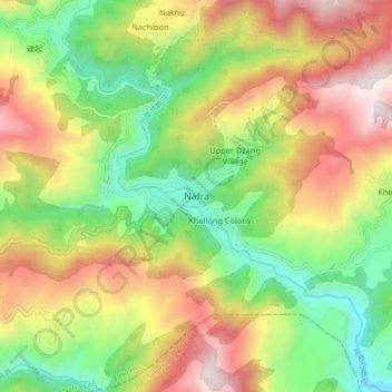
Name: Nafra topographic map, elevation, terrain.

Location: Nafra, Nafra EAC, Bichom, Arunachal Pradesh, India (27.33166 92.50509 27.41166 92.58509)

Average elevation: 1,453 m

Minimum elevation: 814 m

Maximum elevation: 2,262 m

Gear up for your next adventure:

🥾Trekking Poles - Adjustable trekking poles to reduce knee stress and improve stability
🥾Mountain Trail Shoes - High-traction shoes for mountain trails
🥾Trail Running Boots - Durable shoes designed for trail running
🛶Kayak Accessories - Essential gear for safe and fun kayaking adventures
🔦UV Flashlight - Detect minerals or specific insects in the dark

As an Amazon Associate, this site earns from qualifying purchases at no extra cost to you.