Geolocate

Grass Lake topographic map

Click on the map to display elevation.

About this map

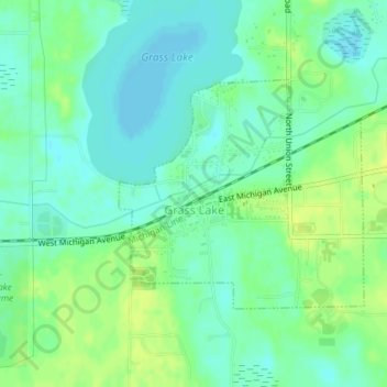
Name: Grass Lake topographic map, elevation, terrain.

Location: Grass Lake, Jackson County, Michigan, United States (42.24395 -84.22013 42.25995 -84.19701)

Average elevation: 304 m

Minimum elevation: 296 m

Maximum elevation: 314 m

Other topographic maps

Click on a map to view its topography, its elevation and its terrain.

Liberty

United States > Michigan > Jackson County

Average elevation: 312 m

White Lake

United States > Michigan > Jackson County

Average elevation: 288 m

Sherman Lake

United States > Michigan > Jackson County

Average elevation: 295 m

Gear up for your next adventure:

🥾Mountain Hiking Boots - High-traction boots for rocky terrain
🕶️Polarized Sunglasses - Reduces glare from snow and water at high elevations
🧦Outdoor Socks - Durable socks designed for hiking and outdoor sports
🛶Canoe Life Vest - Safety vest for water sports
🧭GPS Tracker - Track your location in remote areas safely

As an Amazon Associate, this site earns from qualifying purchases at no extra cost to you.