Geolocate

Polleur topographic map

Click on the map to display elevation.

About this map

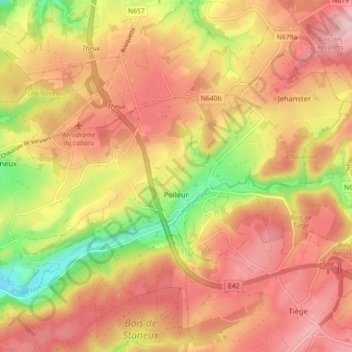
Name: Polleur topographic map, elevation, terrain.

Location: Polleur, Theux, Verviers, Liège, Wallonia, 4910, Belgium (50.51831 5.83198 50.56763 5.92114)

Average elevation: 307 m

Minimum elevation: 141 m

Maximum elevation: 383 m

Other topographic maps

Click on a map to view its topography, its elevation and its terrain.

Vert Buisson

Belgium > Liège > Verviers > Theux

Average elevation: 403 m

Gear up for your next adventure:

🧥Ultralight Puffy Jacket - Maximum warmth that packs down to the size of an orange
🔦LED Headlamp - Hands-free lighting for early morning starts or late finishes
🔭Compact Binoculars - Lightweight optics for scouting trails and wildlife
🥾Mountain Hiking Shoes - Shoes with superior grip for mountainous terrain
🛏️Sleeping Bag - Warm and compact sleeping bags for outdoor camping

As an Amazon Associate, this site earns from qualifying purchases at no extra cost to you.