Geolocate

Habra topographic map

Click on the map to display elevation.

Habra

Habra is located at 22°50′N 88°38′E / 22.83°N 88.63°E / 22.83; 88.63. It has an average elevation of 13 metres (42 feet).

Wikipedia (CC-BY-SA 3.0)

About this map

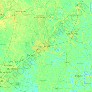
Name: Habra topographic map, elevation, terrain.

Location: Habra, Habra - I, North 24 Parganas, West Bengal, 743263, India (22.68006 88.50307 23.00006 88.82307)

Average elevation: 7 m

Minimum elevation: -3 m

Maximum elevation: 18 m

Gear up for your next adventure:

🛏️Sleeping Bag - Warm and compact sleeping bags for outdoor camping
🥾Trekking Boots - Durable boots for long-distance trekking
🦶Anti-Blister Balm - Prevents friction and hotspots during long ascents
Lightweight Backpacking Tent - Compact tent for efficient hiking trips
Lightweight Camping Tent - Portable shelter optimized for Canadian backcountry camping

As an Amazon Associate, this site earns from qualifying purchases at no extra cost to you.