
Make a donation
Gear up for your next adventure:
As an Amazon Associate, this site earns from qualifying purchases at no extra cost to you.
Gemlik topographic map
Click on the map to display elevation.
Make a donation
Gear up for your next adventure:
As an Amazon Associate, this site earns from qualifying purchases at no extra cost to you.
Gemlik
Gemlik has a hot-summer Mediterranean climate (Köppen climate classification: Csa') with cool and rainy winters, and hot and dry summers. The driest month is July with an average of 22 mm (0.87 in) of rainfall. The wettest month is December with an average of 98 mm (3.9 in) of precipitation. Although a Mediterranean climate generally prevails in the district of Gemlik, the higher elevations have an Oceanic climate (Köppen climate classification: Cfb). The record high temperature is 42.6 °C (109 °F) and the record low temperature is −25.7 °C (−14 °F). The annual precipitation ranges between 456.2 mm (17.96 in) and 1,217.4 mm (47.93 in). The are an average 113 days with precipitation. The warmest month of the year is July, with an average temperature of 23.3 °C (74 °F). The coldest month of the year is January, with an average temperature of 5.8 °C (42 °F).
Make a donation
Gear up for your next adventure:
As an Amazon Associate, this site earns from qualifying purchases at no extra cost to you.
About this map
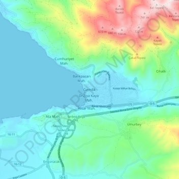
Name: Gemlik topographic map, elevation, terrain.
Location: Gemlik, Bursa, Marmara Region, 16600, Turkey (40.39017 29.11707 40.47017 29.19707)
Average elevation: 179 m
Minimum elevation: 0 m
Maximum elevation: 790 m
Make a donation
Gear up for your next adventure:
As an Amazon Associate, this site earns from qualifying purchases at no extra cost to you.