Geolocate

Lake Junaluska topographic map

Click on the map to display elevation.

About this map

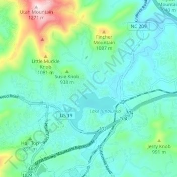
Name: Lake Junaluska topographic map, elevation, terrain.

Location: Lake Junaluska, Haywood County, North Carolina, 28745, United States (35.50940 -83.00510 35.55147 -82.94060)

Average elevation: 862 m

Minimum elevation: 757 m

Maximum elevation: 1,269 m

Other topographic maps

Click on a map to view its topography, its elevation and its terrain.

Cove

United States > North Carolina > Haywood County

Average elevation: 925 m

Mollie Gap

United States > North Carolina > Haywood County

Average elevation: 1,464 m

Green Knob

United States > North Carolina > Haywood County

Average elevation: 1,254 m

The Glades

United States > North Carolina > Haywood County

Average elevation: 1,164 m

Gear up for your next adventure:

👟Leg Gaiters - Keep debris, mud, and snow out of your boots
🧢Beanie Hat - Keep your head warm in cold weather
🧢Sun Protection Cap - Breathable cap to protect from sun exposure
💧Collapsible Water Bottle - Space-saving water bottle for outdoor activities
🧢Hiking Hat - Sun-protective and breathable hats for long treks

As an Amazon Associate, this site earns from qualifying purchases at no extra cost to you.