Geolocate

Redland topographic map

Click on the map to display elevation.

About this map

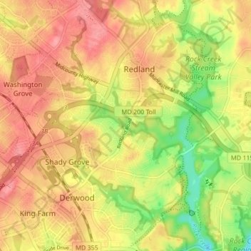
Name: Redland topographic map, elevation, terrain.

Location: Redland, Montgomery County, Maryland, 20855, United States (39.10600 -77.17777 39.15938 -77.11515)

Average elevation: 136 m

Minimum elevation: 87 m

Maximum elevation: 169 m

Gear up for your next adventure:

🧊Insulated Water Bottle - Keeps drinks cold in summer and prevents freezing in winter
💧Reusable Water Bottle - Durable water bottles for hydration on trails
🥾Trail Hiking Socks - Comfortable socks to prevent blisters and fatigue
🥽Outdoor Goggles - Protective eyewear for outdoor activities
🛏️Sleeping Bag - Warm and compact sleeping bags for outdoor camping

As an Amazon Associate, this site earns from qualifying purchases at no extra cost to you.