Geolocate

Valeyre topographic map

Click on the map to display elevation.

About this map
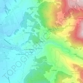
Name: Valeyre topographic map, elevation, terrain.

Location: Valeyre, Ambert, Puy-de-Dôme, Auvergne-Rhône-Alpes, France métropolitaine, 63600, France (45.52619 3.75485 45.56619 3.79485)

Average elevation: 692 m

Minimum elevation: 531 m

Maximum elevation: 1,052 m

Other topographic maps

Click on a map to view its topography, its elevation and its terrain.

Valeyre

France > Auvergne-Rhône-Alpes > Puy-de-Dôme > Ambert

Average elevation: 668 m

63600

France > Auvergne-Rhône-Alpes > Puy-de-Dôme > Ambert > Goyes

Average elevation: 897 m

Gear up for your next adventure:

🧥Softshell Jacket - Windproof and breathable jacket for hiking
🧰Survival Kit - Essential gear for emergencies in the wilderness
🪜Heavy Duty Carabiners - Multi-use clips for securing gear to your backpack
🧤Insulated Winter Gloves - Heavy-duty protection for sub-zero Canadian adventures
💡Solar Camping Lamp - Eco-friendly lighting for campsites

As an Amazon Associate, this site earns from qualifying purchases at no extra cost to you.