
Le Voide topographic map
Click on the map to display elevation.
About this map
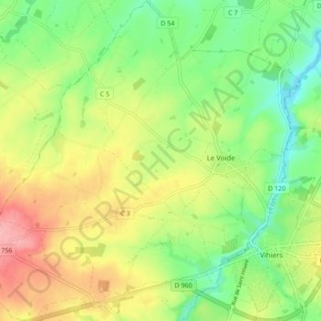
Name: Le Voide topographic map, elevation, terrain.
Average elevation: 106 m
Minimum elevation: 55 m
Maximum elevation: 173 m
Other topographic maps
Click on a map to view its topography, its elevation and its terrain.
Champs des Oisillons
France > Pays de la Loire > Maine-et-Loire > Lys-Haut-Layon > Les Oisillons
Average elevation: 92 m
Le Crétail
France > Pays de la Loire > Maine-et-Loire > Lys-Haut-Layon > La Roche Coutant
Average elevation: 81 m
Saint-Hilaire-du-Bois
France > Pays de la Loire > Maine-et-Loire > Lys-Haut-Layon
Average elevation: 115 m
Étang du Lys
France > Pays de la Loire > Maine-et-Loire > Lys-Haut-Layon > Le Pont du Lys
Average elevation: 99 m