Geolocate

Dolores topographic map

Click on the map to display elevation.

About this map

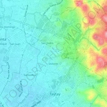
Name: Dolores topographic map, elevation, terrain.

Location: Dolores, Taytay, Rizal, Calabarzon, 1920, Philippines (14.55895 121.13001 14.58698 121.16894)

Average elevation: 33 m

Minimum elevation: -1 m

Maximum elevation: 140 m

Other topographic maps

Click on a map to view its topography, its elevation and its terrain.

Taytay River

Philippines > Rizal > Taytay

Average elevation: 15 m

Havila

Philippines > Rizal > Taytay

Average elevation: 106 m

Taytay River

Philippines > Rizal > Taytay

Average elevation: 5 m

Gear up for your next adventure:

Camping Groundsheet - Protect your tent from moisture and dirt
🧰Emergency Multi-Tool - Compact multi-tool for outdoor survival
🩹Moleskin Blister Pads - Direct protection for painful foot pressure points
🛏️Sleeping Bag - Warm and compact sleeping bags for outdoor camping
🛶Kayak Dry Bag - Waterproof storage for kayaking adventures

As an Amazon Associate, this site earns from qualifying purchases at no extra cost to you.