
Thank you for supporting this site ❤️
Make a donation
Make a donation
Gear up for your next adventure:
As an Amazon Associate, this site earns from qualifying purchases at no extra cost to you.
Feigères topographic map
Click on the map to display elevation.
Thank you for supporting this site ❤️
Make a donation
Make a donation
Gear up for your next adventure:
As an Amazon Associate, this site earns from qualifying purchases at no extra cost to you.
About this map
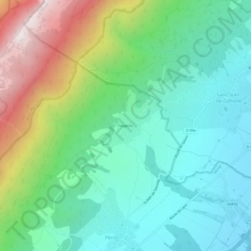
Name: Feigères topographic map, elevation, terrain.
Average elevation: 769 m
Minimum elevation: 466 m
Maximum elevation: 1,493 m
Thank you for supporting this site ❤️
Make a donation
Make a donation
Gear up for your next adventure:
As an Amazon Associate, this site earns from qualifying purchases at no extra cost to you.
Other topographic maps
Click on a map to view its topography, its elevation and its terrain.
Zone Quietude Faune Sauvage Col du Sac - Gralet - Poutouille
France > Auvergne-Rhône-Alpes > Ain > Péron
Average elevation: 1,005 m