
Gerolsbach topographic map
Click on the map to display elevation.
About this map
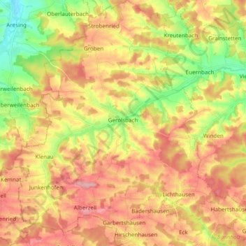
Name: Gerolsbach topographic map, elevation, terrain.
Average elevation: 491 m
Minimum elevation: 422 m
Maximum elevation: 550 m
Other topographic maps
Click on a map to view its topography, its elevation and its terrain.
Straßhöfe
Deutschland > Bayern > Landkreis Pfaffenhofen an der Ilm > Rohrbach an der Ilm
Average elevation: 426 m
Holzleiten
Deutschland > Bayern > Landkreis Pfaffenhofen an der Ilm > Geisenfeld
Average elevation: 386 m
Gotteshofen
Deutschland > Bayern > Landkreis Pfaffenhofen an der Ilm > Reichertshofen > Reichertshofen
Average elevation: 388 m
Pleiling
Deutschland > Bayern > Landkreis Pfaffenhofen an der Ilm > Vohburg an der Donau > Pleiling
Average elevation: 400 m
Untermettenbach
Deutschland > Bayern > Landkreis Pfaffenhofen an der Ilm > Geisenfeld > Untermettenbach
Average elevation: 420 m
Fahlenbach
Deutschland > Bayern > Landkreis Pfaffenhofen an der Ilm > Rohrbach
Average elevation: 412 m
Weingarten
Deutschland > Bayern > Landkreis Pfaffenhofen an der Ilm > Pfaffenhofen an der Ilm > Haimpertshofen
Average elevation: 451 m
Fürholzen
Deutschland > Bayern > Landkreis Pfaffenhofen an der Ilm > Rohrbach
Average elevation: 432 m
Haimpertshofen
Deutschland > Bayern > Landkreis Pfaffenhofen an der Ilm > Pfaffenhofen an der Ilm
Average elevation: 448 m
Eichelberg
Deutschland > Bayern > Landkreis Pfaffenhofen an der Ilm > Geisenfeld
Average elevation: 402 m
Engelbrechtsmünster
Deutschland > Bayern > Landkreis Pfaffenhofen an der Ilm > Geisenfeld
Average elevation: 383 m
Siebeneichmühle
Deutschland > Bayern > Landkreis Pfaffenhofen an der Ilm > Pfaffenhofen an der Ilm > Affalterbach
Average elevation: 440 m
Wasenstatt
Deutschland > Bayern > Landkreis Pfaffenhofen an der Ilm > Pfaffenhofen an der Ilm > Göbelsbach
Average elevation: 451 m
Gambach
Deutschland > Bayern > Landkreis Pfaffenhofen an der Ilm > Rohrbach an der Ilm
Average elevation: 440 m
Hög
Deutschland > Bayern > Landkreis Pfaffenhofen an der Ilm > Reichertshofen
Average elevation: 410 m
Tegernbach
Deutschland > Bayern > Landkreis Pfaffenhofen an der Ilm > Pfaffenhofen an der Ilm > Tegernbach
Average elevation: 458 m
Knodorf
Deutschland > Bayern > Landkreis Pfaffenhofen an der Ilm > Vohburg an der Donau
Average elevation: 360 m
Rottenegg
Deutschland > Bayern > Landkreis Pfaffenhofen an der Ilm > Geisenfeld
Average elevation: 439 m
Affalterbach
Deutschland > Bayern > Landkreis Pfaffenhofen an der Ilm > Pfaffenhofen an der Ilm > Affalterbach
Average elevation: 439 m
Siebeneich
Deutschland > Bayern > Landkreis Pfaffenhofen an der Ilm > Kohlstatt > Siebeneich
Average elevation: 497 m
Jebertshausen
Deutschland > Bayern > Landkreis Pfaffenhofen an der Ilm > Wolnzach > Jebertshausen
Average elevation: 449 m
Egg
Deutschland > Bayern > Landkreis Pfaffenhofen an der Ilm > Wolnzach > Egg
Average elevation: 482 m
Sankt Kastl
Deutschland > Bayern > Landkreis Pfaffenhofen an der Ilm > Stöffel > Sankt Kastl
Average elevation: 432 m
Hagberg
Deutschland > Bayern > Landkreis Pfaffenhofen an der Ilm > Hettenshausen
Average elevation: 453 m
Oberhartheim
Deutschland > Bayern > Landkreis Pfaffenhofen an der Ilm > Vohburg an der Donau
Average elevation: 394 m
Rottenegg
Deutschland > Bayern > Landkreis Pfaffenhofen an der Ilm > Geisenfeld
Average elevation: 439 m