
Make a donation
Gear up for your next adventure:
As an Amazon Associate, this site earns from qualifying purchases at no extra cost to you.
Kolombangara topographic map
Click on the map to display elevation.
Make a donation
Gear up for your next adventure:
As an Amazon Associate, this site earns from qualifying purchases at no extra cost to you.
Kolombangara
Almost perfectly round in shape and about 30 km (19 miles) across, the island is a stratovolcano that reaches an elevation of 1,770 metres (5,807 ft) at Mount Veve. The island forms part of the southern boundary of the New Georgia Sound; to the northwest the Vella Gulf separates it from Vella Lavella and Gizo, while to the southeast New Georgia lies across the Kula Gulf. West-southwest of Kolombangara is Ghizo Island, upon which the Western provincial capital Gizo is located. The island is heavily forested, with few inhabitants. There are two notable settlements, Ringgi and Mongga, the former being the larger. The most significant industry on the island is logging, principally based at Poitete.
Make a donation
Gear up for your next adventure:
As an Amazon Associate, this site earns from qualifying purchases at no extra cost to you.
About this map
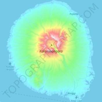
Name: Kolombangara topographic map, elevation, terrain.
Location: Kolombangara, Western, Solomon Islands (-8.13890 156.93748 -7.84179 157.19780)
Average elevation: 198 m
Minimum elevation: -3 m
Maximum elevation: 1,746 m
Make a donation
Gear up for your next adventure:
As an Amazon Associate, this site earns from qualifying purchases at no extra cost to you.
Other topographic maps
Click on a map to view its topography, its elevation and its terrain.
Make a donation
Gear up for your next adventure:
As an Amazon Associate, this site earns from qualifying purchases at no extra cost to you.