
Thank you for supporting this site ❤️
Make a donation
Make a donation
Gear up for your next adventure:
As an Amazon Associate, this site earns from qualifying purchases at no extra cost to you.
Murgud topographic map
Click on the map to display elevation.
Thank you for supporting this site ❤️
Make a donation
Make a donation
Gear up for your next adventure:
As an Amazon Associate, this site earns from qualifying purchases at no extra cost to you.
About this map
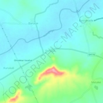
Name: Murgud topographic map, elevation, terrain.
Location: Murgud, Kagal, Kolhapur district, Maharashtra, 416219, India (16.40779 74.24311 16.44779 74.28311)
Average elevation: 567 m
Minimum elevation: 542 m
Maximum elevation: 665 m
Thank you for supporting this site ❤️
Make a donation
Make a donation
Gear up for your next adventure:
As an Amazon Associate, this site earns from qualifying purchases at no extra cost to you.