
Thank you for supporting this site ❤️
Make a donation
Make a donation
Gear up for your next adventure:
As an Amazon Associate, this site earns from qualifying purchases at no extra cost to you.
Borlasca topographic map
Click on the map to display elevation.
Thank you for supporting this site ❤️
Make a donation
Make a donation
Gear up for your next adventure:
As an Amazon Associate, this site earns from qualifying purchases at no extra cost to you.
About this map
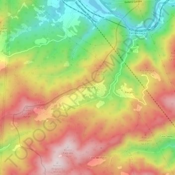
Name: Borlasca topographic map, elevation, terrain.
Location: Borlasca, Isola del Cantone, Genova, Liguria, 15061, Italia (44.62516 8.88636 44.66516 8.92636)
Average elevation: 517 m
Minimum elevation: 233 m
Maximum elevation: 780 m
Thank you for supporting this site ❤️
Make a donation
Make a donation
Gear up for your next adventure:
As an Amazon Associate, this site earns from qualifying purchases at no extra cost to you.