
Make a donation
Gear up for your next adventure:
As an Amazon Associate, this site earns from qualifying purchases at no extra cost to you.
Moscano topographic map
Click on the map to display elevation.
Make a donation
Gear up for your next adventure:
As an Amazon Associate, this site earns from qualifying purchases at no extra cost to you.
Moscano
Moscano si trova a un'altitudine di 456 m s.l.m., è un piccolo paese collinare che si trova tra il monte Remosse e il monte Conche. Il paese è suddiviso in due parti: la parte inferiore dove è presente anche una piccola chiesa, e la parte superiore detta Reggiano.
Make a donation
Gear up for your next adventure:
As an Amazon Associate, this site earns from qualifying purchases at no extra cost to you.
About this map
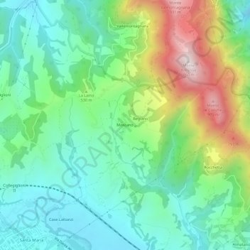
Name: Moscano topographic map, elevation, terrain.
Location: Moscano, Fabriano, Ancona, 60040, Italia (43.34951 12.92890 43.38951 12.96890)
Average elevation: 465 m
Minimum elevation: 252 m
Maximum elevation: 943 m
Make a donation
Gear up for your next adventure:
As an Amazon Associate, this site earns from qualifying purchases at no extra cost to you.