Geolocate

Noney topographic map

Click on the map to display elevation.

About this map

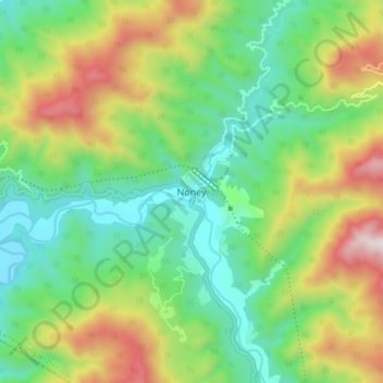
Name: Noney topographic map, elevation, terrain.

Location: Noney, Tamenglong, Manipur, 795159, India (24.82259 93.58375 24.90259 93.66375)

Average elevation: 670 m

Minimum elevation: 275 m

Maximum elevation: 1,400 m

Gear up for your next adventure:

🧰Survival Kit - Essential gear for emergencies in the wilderness
🧴Outdoor Sunscreen - High SPF protection for high-altitude UV exposure
🛶Kayak Dry Bag - Waterproof storage for kayaking adventures
🧶550 Survival Paracord - Versatile utility cord for emergency repairs and rigging
🧰Multitool Knife - Compact and versatile tool for outdoor use

As an Amazon Associate, this site earns from qualifying purchases at no extra cost to you.