
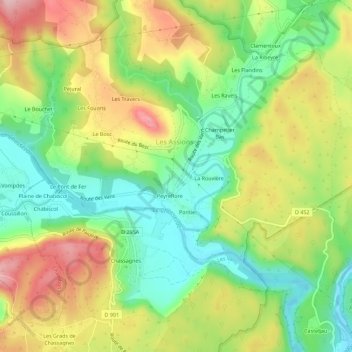
Les Massots topographic map
Interactive map
Click on the map to display elevation.
About this map
Name: Les Massots topographic map, elevation, terrain.
Average elevation: 213 m
Minimum elevation: 118 m
Maximum elevation: 336 m
Other topographic maps
Click on a map to view its topography, its elevation and its terrain.
Champetier Bas
France > Auvergne-Rhône-Alpes > Ardèche > Les Assions
Champetier Bas, Les Assions, Largentière, Ardèche, Auvergne-Rhône-Alpes, France métropolitaine, 07140, France
Average elevation: 216 m
La Ribeyre
France > Auvergne-Rhône-Alpes > Ardèche > Les Assions
La Ribeyre, Les Assions, Largentière, Ardèche, Auvergne-Rhône-Alpes, France métropolitaine, 07140, France
Average elevation: 231 m
Pontier
France > Auvergne-Rhône-Alpes > Ardèche > Les Assions > Pontier
Pontier, Les Assions, Largentière, Ardèche, Auvergne-Rhône-Alpes, France métropolitaine, 07140, France
Average elevation: 209 m
Le Pont de Fer
France > Auvergne-Rhône-Alpes > Ardèche > Les Assions
Le Pont de Fer, Les Assions, Largentière, Ardèche, Auvergne-Rhône-Alpes, France métropolitaine, 07140, France
Average elevation: 210 m