Geolocate

Afton topographic map

Click on the map to display elevation.

About this map

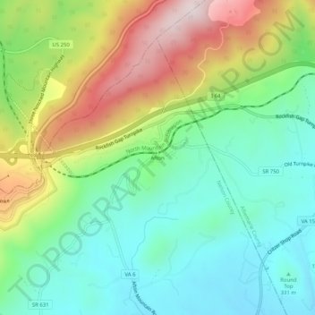
Name: Afton topographic map, elevation, terrain.

Location: Afton, Nelson County, Virginia, 22920, United States (38.01236 -78.85919 38.05236 -78.81919)

Average elevation: 439 m

Minimum elevation: 235 m

Maximum elevation: 815 m

Other topographic maps

Click on a map to view its topography, its elevation and its terrain.

Piney River

United States > Virginia > Nelson County

Average elevation: 266 m

Tye River

United States > Virginia > Nelson County

Average elevation: 251 m

Gear up for your next adventure:

🧤Insulated Winter Gloves - Heavy-duty protection for sub-zero Canadian adventures
🕶️Polarized Sunglasses - Reduces glare from snow and water at high elevations
🥾Durable Hiking Shoes - Long-lasting shoes for frequent hiking
🪑Insulated Seat Pad - Protect your seat from cold rocks and wet logs
🚲MTB Frame Bag - Carry tools and maps directly on your bicycle frame

As an Amazon Associate, this site earns from qualifying purchases at no extra cost to you.