
Make a donation
Gear up for your next adventure:
As an Amazon Associate, this site earns from qualifying purchases at no extra cost to you.
Gronau topographic map
Click on the map to display elevation.
Make a donation
Gear up for your next adventure:
As an Amazon Associate, this site earns from qualifying purchases at no extra cost to you.
About this map
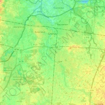
Name: Gronau topographic map, elevation, terrain.
Location: Gronau, Kreis Borken, North Rhine-Westphalia, 48599, Germany (52.13486 6.95042 52.24303 7.10281)
Average elevation: 44 m
Minimum elevation: 31 m
Maximum elevation: 57 m
Make a donation
Gear up for your next adventure:
As an Amazon Associate, this site earns from qualifying purchases at no extra cost to you.
Other topographic maps
Click on a map to view its topography, its elevation and its terrain.
Make a donation
Gear up for your next adventure:
As an Amazon Associate, this site earns from qualifying purchases at no extra cost to you.
Isselburg
Germany > North Rhine-Westphalia > Kreis Borken > Isselburg > Isselburg
Average elevation: 19 m
Zwillbrock
Germany > North Rhine-Westphalia > Kreis Borken > Vreden > Zwillbrock
Average elevation: 31 m
Make a donation
Gear up for your next adventure:
As an Amazon Associate, this site earns from qualifying purchases at no extra cost to you.