
Thank you for supporting this site ❤️
Make a donation
Make a donation
Gear up for your next adventure:
As an Amazon Associate, this site earns from qualifying purchases at no extra cost to you.
Lerona topographic map
Click on the map to display elevation.
Thank you for supporting this site ❤️
Make a donation
Make a donation
Gear up for your next adventure:
As an Amazon Associate, this site earns from qualifying purchases at no extra cost to you.
About this map
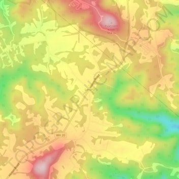
Name: Lerona topographic map, elevation, terrain.
Location: Lerona, Mercer County, West Virginia, 24979, United States (37.47956 -80.99898 37.51956 -80.95898)
Average elevation: 761 m
Minimum elevation: 581 m
Maximum elevation: 897 m
Thank you for supporting this site ❤️
Make a donation
Make a donation
Gear up for your next adventure:
As an Amazon Associate, this site earns from qualifying purchases at no extra cost to you.
Other topographic maps
Click on a map to view its topography, its elevation and its terrain.
Pinnacle Rock State Park
United States > West Virginia > Mercer County > Nemours
Average elevation: 772 m