
Lapland topographic map
Interactive map
Click on the map to display elevation.
About this map
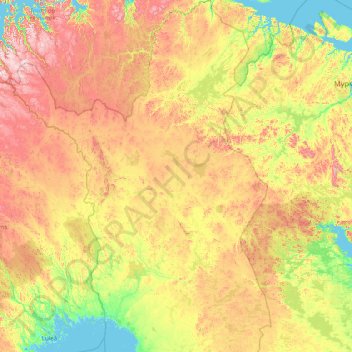
Name: Lapland topographic map, elevation, terrain.
Location: Lapland, Mainland Finland, Finland (65.29248 20.54864 70.09229 30.01567)
Average elevation: 249 m
Minimum elevation: -2 m
Maximum elevation: 1,344 m
Other topographic maps
Click on a map to view its topography, its elevation and its terrain.
Eura
Finland > Mainland Finland > Eura
Eura, Rauman seutukunta, Satakunta, Mainland Finland, Finland
Average elevation: 48 m
Canoe River
Finland > Mainland Finland > Laukaa
Canoe River, Laukaa, Jyväskylä sub-region, Central Finland, Mainland Finland, Finland
Average elevation: 116 m