
Make a donation
Gear up for your next adventure:
As an Amazon Associate, this site earns from qualifying purchases at no extra cost to you.
Bonn topographic map
Click on the map to display elevation.
Make a donation
Gear up for your next adventure:
As an Amazon Associate, this site earns from qualifying purchases at no extra cost to you.
About this map
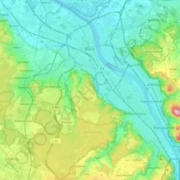
Name: Bonn topographic map, elevation, terrain.
Location: Bonn, North Rhine-Westphalia, Germany (50.63269 7.02254 50.77442 7.21068)
Average elevation: 116 m
Minimum elevation: 44 m
Maximum elevation: 335 m
Make a donation
Gear up for your next adventure:
As an Amazon Associate, this site earns from qualifying purchases at no extra cost to you.
Other topographic maps
Click on a map to view its topography, its elevation and its terrain.
Kierdorf
Germany > North Rhine-Westphalia > Rheinisch-Bergischer Kreis > Bergisch Gladbach > Herkenrath
Average elevation: 189 m
Winterberg
Germany > North Rhine-Westphalia > Hochsauerlandkreis > Winterberg > Winterberg
Average elevation: 648 m
Make a donation
Gear up for your next adventure:
As an Amazon Associate, this site earns from qualifying purchases at no extra cost to you.