
Make a donation
Gear up for your next adventure:
As an Amazon Associate, this site earns from qualifying purchases at no extra cost to you.
Hoyorrico topographic map
Click on the map to display elevation.
Make a donation
Gear up for your next adventure:
As an Amazon Associate, this site earns from qualifying purchases at no extra cost to you.
About this map
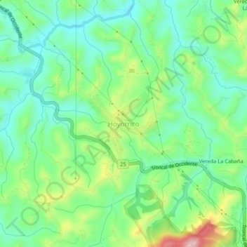
Name: Hoyorrico topographic map, elevation, terrain.
Average elevation: 2,486 m
Minimum elevation: 2,421 m
Maximum elevation: 2,624 m
Make a donation
Gear up for your next adventure:
As an Amazon Associate, this site earns from qualifying purchases at no extra cost to you.
Other topographic maps
Click on a map to view its topography, its elevation and its terrain.
Make a donation
Gear up for your next adventure:
As an Amazon Associate, this site earns from qualifying purchases at no extra cost to you.
Vereda Caruquia Parte Baja y La Palestina
Colombia > Antioquia > Santa Rosa de Osos > Vereda Caruquia Parte Baja y La Palestina
Average elevation: 2,247 m
Make a donation
Gear up for your next adventure:
As an Amazon Associate, this site earns from qualifying purchases at no extra cost to you.
Vereda Los Salados
Colombia > Antioquia > Santa Rosa de Osos > Vereda Los Salados
Average elevation: 2,391 m
Vereda La Pava Salamina
Colombia > Antioquia > Santa Rosa de Osos > Vereda La Pava-Salamina
Average elevation: 1,534 m
Make a donation
Gear up for your next adventure:
As an Amazon Associate, this site earns from qualifying purchases at no extra cost to you.