
Make a donation
Gear up for your next adventure:
As an Amazon Associate, this site earns from qualifying purchases at no extra cost to you.
White County topographic map
Click on the map to display elevation.
Make a donation
Gear up for your next adventure:
As an Amazon Associate, this site earns from qualifying purchases at no extra cost to you.
White County
The county is mostly located in the foothills of the Blue Ridge Mountains. Northern parts of the county have the highest elevations, being in the mountains themselves. The highest point in White County is 4,430-foot (1,350 m) Tray Mountain, shared with Towns County to the north. Tray Mountain is the 6th-highest mountain in Georgia. Another very prominent White County peak is Yonah Mountain, also known as Mount Yonah. This 3,143-foot (958 m) peak, located between Helen and Cleveland, is rimmed by sheer cliffs and is the highest point on Georgia's Piedmont Plateau.
Make a donation
Gear up for your next adventure:
As an Amazon Associate, this site earns from qualifying purchases at no extra cost to you.
About this map
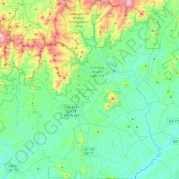
Name: White County topographic map, elevation, terrain.
Location: White County, Georgia, United States (34.50359 -83.87735 34.80137 -83.61559)
Average elevation: 556 m
Minimum elevation: 337 m
Maximum elevation: 1,333 m
Make a donation
Gear up for your next adventure:
As an Amazon Associate, this site earns from qualifying purchases at no extra cost to you.
Other topographic maps
Click on a map to view its topography, its elevation and its terrain.
Make a donation
Gear up for your next adventure:
As an Amazon Associate, this site earns from qualifying purchases at no extra cost to you.