Geolocate

Luyos topographic map

Click on the map to display elevation.

About this map

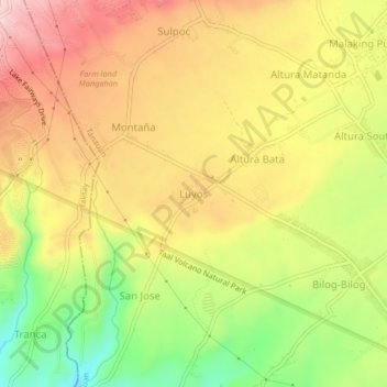
Name: Luyos topographic map, elevation, terrain.

Location: Luyos, Tanauan, Batangas, Calabarzon, 4232, Philippines (14.10323 121.05261 14.14323 121.09261)

Average elevation: 170 m

Minimum elevation: 42 m

Maximum elevation: 277 m

Other topographic maps

Click on a map to view its topography, its elevation and its terrain.

Maria Paz

Philippines > Batangas > Tanauan

Average elevation: 64 m

Barangay 3

Philippines > Batangas > Tanauan > Hidalgo

Average elevation: 158 m

Barangay 5

Philippines > Batangas > Tanauan > Hidalgo

Average elevation: 154 m

Suplang

Philippines > Batangas > Tanauan

Average elevation: 247 m

Barangay 5

Philippines > Batangas > Tanauan > Hidalgo

Average elevation: 154 m

Gear up for your next adventure:

💧Filtered Water Bottle - Safe drinking water on the go
🧥Fleece Jacket - Warm and lightweight jacket for layering
🥾Trail Running Boots - Durable shoes designed for trail running
🎒Hiking Backpack - Lightweight and ergonomic backpacks for day hikes or multi-day treks
💡Compact LED Flashlight - Powerful and portable flashlight for outdoor use

As an Amazon Associate, this site earns from qualifying purchases at no extra cost to you.