Geolocate

Malente topographic map

Click on the map to display elevation.

About this map

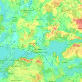
Name: Malente topographic map, elevation, terrain.

Location: Malente, Ostholstein, Schleswig-Holstein, 23714, Germany (54.13266 10.48294 54.23544 10.67612)

Average elevation: 42 m

Minimum elevation: 18 m

Maximum elevation: 97 m

Other topographic maps

Click on a map to view its topography, its elevation and its terrain.

Gear up for your next adventure:

🚲Heavy Duty Bike Lock - Secure your bike at the trailhead or during stops
🔋Solar Power Bank - Keep your GPS and devices charged during long outdoor trips
🧥Softshell Hiking Jacket - The perfect balance of wind protection and breathability
🥾Mountain Hiking Shoes - Shoes with superior grip for mountainous terrain
💧Hydration Bladder - Hands-free hydration solution for long treks

As an Amazon Associate, this site earns from qualifying purchases at no extra cost to you.