
Make a donation
Gear up for your next adventure:
As an Amazon Associate, this site earns from qualifying purchases at no extra cost to you.
Gratz topographic map
Click on the map to display elevation.
Make a donation
Gear up for your next adventure:
As an Amazon Associate, this site earns from qualifying purchases at no extra cost to you.
About this map
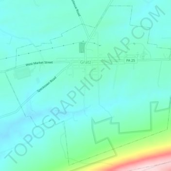
Name: Gratz topographic map, elevation, terrain.
Location: Gratz, Dauphin County, Pennsylvania, United States (40.59186 -76.73910 40.62256 -76.69581)
Average elevation: 247 m
Minimum elevation: 188 m
Maximum elevation: 502 m
Make a donation
Gear up for your next adventure:
As an Amazon Associate, this site earns from qualifying purchases at no extra cost to you.
Other topographic maps
Click on a map to view its topography, its elevation and its terrain.
Singersville
United States > Pennsylvania > Dauphin County > Middle Paxton Township
Average elevation: 187 m
Rockville
United States > Pennsylvania > Dauphin County > Susquehanna Township
Average elevation: 141 m
Shellsville
United States > Pennsylvania > Dauphin County > East Hanover Township
Average elevation: 145 m
Make a donation
Gear up for your next adventure:
As an Amazon Associate, this site earns from qualifying purchases at no extra cost to you.
Manada Gap
United States > Pennsylvania > Dauphin County > East Hanover Township
Average elevation: 203 m
Montrose Park
United States > Pennsylvania > Dauphin County > Susquehanna Township
Average elevation: 105 m
Piketown
United States > Pennsylvania > Dauphin County > West Hanover Township
Average elevation: 195 m
Make a donation
Gear up for your next adventure:
As an Amazon Associate, this site earns from qualifying purchases at no extra cost to you.
Powells Valley
United States > Pennsylvania > Dauphin County > Halifax Township
Average elevation: 179 m
Hanoverdale
United States > Pennsylvania > Dauphin County > West Hanover Township
Average elevation: 143 m
Heckton
United States > Pennsylvania > Dauphin County > Middle Paxton Township
Average elevation: 155 m
Make a donation
Gear up for your next adventure:
As an Amazon Associate, this site earns from qualifying purchases at no extra cost to you.
Hoernerstown
United States > Pennsylvania > Dauphin County > South Hanover Township
Average elevation: 132 m
Killinger
United States > Pennsylvania > Dauphin County > Upper Paxton Township
Average elevation: 176 m
Grantville
United States > Pennsylvania > Dauphin County > East Hanover Township
Average elevation: 143 m
Make a donation
Gear up for your next adventure:
As an Amazon Associate, this site earns from qualifying purchases at no extra cost to you.
Union Deposit
United States > Pennsylvania > Dauphin County > South Hanover Township
Average elevation: 125 m
Bachmanville
United States > Pennsylvania > Dauphin County > Conewago Township
Average elevation: 165 m
Make a donation
Gear up for your next adventure:
As an Amazon Associate, this site earns from qualifying purchases at no extra cost to you.
Beaufort Farms
United States > Pennsylvania > Dauphin County > Susquehanna Township
Average elevation: 131 m
Make a donation
Gear up for your next adventure:
As an Amazon Associate, this site earns from qualifying purchases at no extra cost to you.
Carsonville
United States > Pennsylvania > Dauphin County > Jefferson Township
Average elevation: 270 m
Edgemont
United States > Pennsylvania > Dauphin County > Susquehanna Township
Average elevation: 138 m
Lenkerville
United States > Pennsylvania > Dauphin County > Upper Paxton Township
Average elevation: 156 m
Make a donation
Gear up for your next adventure:
As an Amazon Associate, this site earns from qualifying purchases at no extra cost to you.
Locust Lane Gardens
United States > Pennsylvania > Dauphin County > Colonial Park > Locust Lane Gardens
Average elevation: 147 m
Twin Lakes Park
United States > Pennsylvania > Dauphin County > Twin Lakes Park
Average elevation: 146 m
Make a donation
Gear up for your next adventure:
As an Amazon Associate, this site earns from qualifying purchases at no extra cost to you.