Geolocate

Canton topographic map

Click on the map to display elevation.

About this map

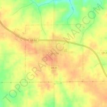
Name: Canton topographic map, elevation, terrain.

Location: Canton, Fillmore County, Minnesota, United States (43.52237 -91.94358 43.53692 -91.91962)

Average elevation: 403 m

Minimum elevation: 375 m

Maximum elevation: 416 m

Other topographic maps

Click on a map to view its topography, its elevation and its terrain.

Chatfield

United States > Minnesota > Fillmore County

Average elevation: 327 m

Highland

United States > Minnesota > Fillmore County

Average elevation: 351 m

Gear up for your next adventure:

🚲Bike Repair Kit - Essential tools for on-trail mechanical issues
🥾Light Trekking Boots - Supportive boots for multi-day treks
🍽️Titanium Camping Spork - Ultralight and indestructible eating utensil
🥾Approach Boots - Comfortable boots for hiking and climbing approaches
🧴Insect Repellent - Protect yourself from bugs during outdoor adventures

As an Amazon Associate, this site earns from qualifying purchases at no extra cost to you.